


Navigation is something we do every day without even considering it. In its simplest terms, navigation is getting from point A to point B. It's fairly easy when the distances are short, and the environs are obvious. Finding your way to the kitchen in your own home, for example. But when the distances grow longer, and if the destination is unfamiliar, then the challenges increase.

When it comes to flying, the variables are many and not insignificant. Distance, darkness, weather, wind, visibility, magnetic fields, and even the earth's curvature all figure into the calculus that must be considered when finding the correct path from A to B. Today, pilots of even the smallest airplanes have the technology of the Global Positioning System (GPS) available to them.
This navigational aid functions when signals are exchanged between a constellation of satellites in orbit, ground-based stations, and GPS-equipped aircraft, informing the pilot of their position in relationship to the earth below (longitude and latitude) as well as its progress through the air mass above it (altitude, airspeed, and course).
The earliest form of aerial navigation was known as "pilotage," another term borrowed from aviation's maritime predecessors, where it meant steering a ship through harbors or other dangerous waterways. Pilotage, or contact flying, is navigation by reference to landmarks or checkpoints and requires visibility.
Naturally, pilotage is only possible in good visibility or darkness. Darkness was such a scourge to early aviation that it wasn't until the 1920s that airmail and passenger service dared attempt it, guided t first by bonfires set at regular intervals along a given course, then later by a system of beacon stations like the ones that stretched across the American continent both east-west and north-south.

By day, airmail pilots followed giant cement arrows placed on the ground along routes between destination cities. By night, each beacon station featured a fifty-foot skeleton tower upon which rested a rotating beacon of 24 to 36 inches (61 to 91 centimeters) in diameter. Many of these beacon stations have been preserved and can still be seen today from Pennsylvania to the West Coast).
With the invention of aircraft instrumentation came the ability to navigate by calculating one's position without seeing landmarks at all. Knowing one's airspeed and compass heading, for example, along with the speed and direction of any wind, allowed navigators to deduce their position based on the time, distance, and direction of flight. Thus, the term "dead" reckoning, where "dead" is derived from DEDuced.
Pilotage and dead reckoning are still taught in basic flight training today. After all, an electronic instrument such as a GPS receiver could fail. Can pilots find their way with just a map and what they see out the plane's window? In this regard, a great debt is owed to an early airmail pilot named Elrey Jeppesen. When Jeppesen was hired by Boeing Air Transport in 1930, pilots still relied on automobile road maps or followed the railroad tracks, affectionately called "flying the iron compass."
Jeppesen purchased a simple notebook and began collecting details of the routes he flew, even going as far as visiting certain landmarks to determine the heights of terrain features and collecting the phone numbers of farmers willing to provide a weather report when he called. Jeppesen was the first to create "let-down procedures" for descending onto certain destinations in such a way as to avoid known obstacles.
As other pilots inquired about Jeppesen's maps, he established a company to publish them in 1934 and, along with his wife Nadine, ran the company from their Salt Lake City home. Elrey Jeppesen retired from United Airlines in 1954 and sold Jeppesen & Co. in 1961. The Jeppesen Airway Manual is still used today by major airlines. The comprehensive collection of complex data such as GPS and ILS procedures has transitioned into digital formats that allow pilots to access its wealth of data on their in-cockpit displays or tablets, replacing the cumbersome volumes of paper maps they once lugged about in suitcase-like flight kits.
It seems hard to believe that the airplane predated commercial radio by as much as seventeen years. Wireless communication developed slowly at the end of the 19th century, with Nikolai Tesla being one of the inventors involved in its development. "Marconi sets" had been installed on ships in the early years of the 20th century (it is believed that the 700 lives saved from the Titanic were thanks in great part to the crew's ability to transmit their distress call, without which no other ships would have seen or known about the disaster). But radio sets were too heavy and bulky to be installed in the airplanes of the day. The very first radios would not be practical on aircraft until the latter half of the 1920s. In fact, Charles Lindbergh did not carry a radio on his famed solo flight from New York to Paris in May 1927.
The ability to receive radio signals in an aircraft opened the way for electronic navigational aids. The first four-course radio range was established in 1928. All that was needed was a radio receiver, a headset, and a navigation chart. Four ground-based antennas produced two signals, the first being the Morse Code letter N (dash-dot) and the other signal being the letter A (dot-dash). Listening on the headset, the pilot would hear either the N or A tone depending on whether the aircraft was flying to one side or other of the direct course toward the radio station antennas. If the plane were right on course, the dots and dashes of the A and N would mesh into one steady tone. This became known as "flying the beam."
By the end of the 1930s, a system of civil airways, airport radio control towers, and radio ranges allowed pilots to fly across the country and even over the Atlantic using these new technologies. Using voice transmissions, pilots could now share position reports with their company dispatchers, who would then relay them to air traffic controllers to track their progress. This was, of course, before the days of radar. En route, radar coverage, and direct communication between aircraft and air traffic control would not exist until the 1960s. Airports could also now transmit the local weather conditions to approaching and departing pilots.
Navigating the immediate area around an airport was revolutionized by implementing the Instrument Landing Systems (ILS) in 1947. The ILS allowed the pilot to hone in on a decent path leading directly to the desired runway's end. Now pilots could, using a single instrument on their panel, know that they were both vertically and horizontally on the correct glide path and that no obstacles would be in their way. Thus, planes could approach the runway even in low visibility and ceilings as low as a few hundred feet above the ground.
Innovations in communications and electronics led to the proliferation of increasingly more accurate navaids. Such ground-based and aircraft-mounted devices became a major contributor to the stew of common acronyms in aviation: ADF, VOR, VORTAC, DME, NDB, and the like. The ability to equip aircraft with their own on-board radar-based equipment also aided in navigation as well. Ground Proximity Warning Systems (GPWS) and Traffic Collision Avoidance Systems (TCAS) allow pilots to avoid obstacles such as terrain and other aircraft.
A real boon to navigation is weather radar, which provides pilots with real-time information concerning the position and severity of the weather. Such information, independent of ground-based observation, allows aircrew to choose their own course around weather that delays or impedes their flight. Deviation around inclement conditions such as thunderstorms, for example, has also made flying much safer.
Certainly, the Inertial Navigation System, or INS, is one of the most revolutionary developments in modern aerial navigation. Using precise accelerometers mounted on a gyro-stabilized platform, the INS senses any movement of the airplane - its inertia - and processes that information through its computer. Modern INS uses lasers chasing around a triangle rather than accelerometers. Before starting a flight, the plane's position is entered in latitude and longitude very precisely, to several decimal points (right down to the exact gate for a commercial flight at a commercial airport). The INS starts reading the aircraft's speed and direction from the very first movement, even on the ground. In the air, it continually provides the exact latitude, longitude, ground speed, and drift.

An amazing feature of INS is its independence from anything outside the airplane. The self-contained INS does not rely on ground stations, satellites, or communication systems of any kind. Thus, even if such systems are affected by malfunction or disaster below- weather, earthquakes, war, etc. - the INS will continue to function. The first airliners to use the INS included the early Boeing 747 (models -100 through -300) and the Lockheed L-1011 TriStar, which both began service in the first few years of the 1970s. Such aircraft carried triple-redundant INS systems, the resulting course calculations being an average of the three.
INS has been adopted into the general operation of Flight Management Systems (FMS), the onboard multi-purpose navigation, performance, and aircraft operations computer that has been the basis of most glass cockpits since the 1980s. As part of the Inertial Reference System (IRS), the INS works in concert with GPS and ground-based systems to feed the "moving map" function with its now-famous magenta line.
In all likelihood, future aerial navigation will be driven by the rapid advancements enjoyed in computing capacity, automation, ubiquitous communication methods, and artificial intelligence. The FAA holds a vision for an "Info-Centric National Airspace System." This NextGen navigation vision includes implementing Trajectory Based Operations (TBO). This system expedites aircraft movement between airports by assisting pilots and air traffic controllers balance system capacity and demand to minimize disruptions such as bad weather and improve operational predictability and flexibility. According to a 2023 report by the research corporation MITRE, GPS will be a foundational building block of such NextGen operations.

Another building block, the "connected aircraft," will be made possible by broadband communications with aviation-specific infrastructure. Similarly, mobile connectivity will play a role in information exchange. Devices such as tablets and smartphones will play a vital role in commercial, business, and general aviation. The MITRE-developed "Digital Copilot," for example, assists solo pilots and has the potential to significantly reduce the rates of accidents in general aviation. Tablets loaded with complex flight planning and navigation apps such as ForeFlight (TM) are already commonplace in general aviation cockpits.
In the novel "Where Is Joe Merchant?" by the late music star and accomplished aviator Jimmy Buffet, a down-on-his-luck seaplane pilot named Frank Bama declares, "The best navigators aren't sure where they are until they get there, and then they're STILL not sure!" A constellation of satellites in geosynchronous orbit around the planet and the proliferation of glowing tablet screens may be taking some of the mystery out of navigating from point A to point B. Gone is the romance of the night flight across the dark ocean and the navigator popping his head up into the plexiglass dome to shoot the stars with a sextant or the pilots lowering into Chicago to have a "look-see" for a glimpse of the streetlights of Cicero Avenue that would point them toward the old Orchard Airfield (ORD). But with the elimination of this uncertainty comes increased safety, efficiency, and economic advantage.
As the saying goes, "Aviation in itself is not inherently dangerous. But to an even greater degree than the sea, it is terribly unforgiving of any carelessness, incapacity, or neglect." Navigation will never be completely free of the need for good judgment, reckoning, and maybe a little luck, as the body of air through which aircraft fly is ever-changing and never constant. But as navigation tools have improved, we can hope that with them, the capacity of humankind to benefit from an increasingly smaller and better-connected world will increase as well.
FormAlloy is Eliminating CAD in High-Precision Industrial Additive Manufacturing » United Flight UA2005 Diverted After Passenger Attempts to Access Cockpit » Italy Considers Long-Haul Business-Class-Only Flights Between New York and Milan Linate »

Comments (15)
 Allan Bowman
Excellent article. What has always amazed me is the ability of early bush pilots to find anything on their flights over the northern wilderness of north america. Nothing but flat, rocks, trees, water, in an endless pattern. They did so often at low altitudes under clouds where it is difficult to even see patterns of lakes. These guys were unbelievable navigators.
Edward
Amen! To borrow a quote from a famous "aviation movie," it's a whole different kind of flying altogether!
Jim
Great article, Ed! Thank you! I remember some of the earlier days, not the beginnings though. I learned all the items of dead reckoning, flying the beam, using manual direction finding, using the beacons at night, etc. The U.S. Navy did a good job of letting me fly for some 30 years. It was a grand time to experience the transition from what could be seen (pilotage) to all the grand help that is available to pilots of today (I flew privately until age 88).
I believe we had air traffic control in parts of the U.S.A. in the 1940's and 50's. I remember my first venture into NYC in 1953. They wanted to talk! Thanks, again, for the well-done article.
Edward
Jim,
Thank you so much for your comments. Wow, your career has covered such a broad and amazing part of aviation history. Have you written it all down for posterity?
Brent
Interesting that you did not really mention celestial navigation. As a former U.S. AirForce Navigator , I felt I needed to point this error out. Celestial Navigation was used by the AirForce and Navy from WWII on. There are no beacons and radio stations in the oceans. Navigating by the stars was the mainstay for decades for ocean flights and is still being taught. The major Airlines used it for years until INS and GPS came along. Celestial navigation was supplemented by LORAN in the years just before GPS became available. The stars are always there and don't lie. The sam cannot be said for radio or satellite navigation.
Edward
Brent,
Thanks for your comments and your service to our country. Sadly, in the interest of time and space I chose to leave out celestial navigation. But it is fascinating, and will a make a great article all by itself. In his autobiography "North Star Over My Shoulder,' the late Capt. Bob Buck of TWA does a great job of discussing it in the context of flying a B-17 called "Two Kind Words" (in TWA colors!) around the world doing weather experiments during World War II. The dome was on the nose, directly in front of the cockpit, and he wrote about watching his navigator pop up and shoot the stars. I'd personally love to learn how to use a sextant.
Kevin Donaghey
What?
Are you kidding?
You did what you needed to do.
You may as well ask how did people have sex, before the internet.
Edward
In the age of AI girlfriends, we may have to soon!
Richard Hagemeyer
Excellent article. I was an Air Force meteorologist and have always enjoyed hearing these facts and stories. My story of air navigation that has always puzzled me was on an Aeroflot flight from Moscow to Ekaterinburg in Feb 1997. We were on finall “forever”, maybe 2000’ AGL. We landed at Chelyabinsk, the wrong airport a good 200km from our actual destination. They made no announcement as to why and I always wondered what was going on in the cockpit. Never flew Aeroflot again.
Edward
That's a grate story! Aeroflot provides many such memories. I had the experience of flying on them in 1990 on a Tu- 154 to Minsk. Even though it was near midnight, we were still flying in sunshine in summertime, parallel to a set of contrails that stretched the entire way to our destination. I assumed that was the only method of navigation they needed!
George
You may know something I don't. The lights of Cicero Avenue would lead a pilot to MDW not ORD. You'd follow the Mannheim Road lights to ORD back before the Tri-State and the Kennedy.
Edward
You are correct, sir! I misremembered an anecdote about a DC-3 crew dropping in for a "look-see" on an evening of poor visibility over the Windy City. I'll put it in to get that fixed!
Rob Roy
I am a former Maine Guide and a former Naval Flight Officer, trained at the Air Force advanced navigation school In Sacramento in the late 70s. As a navigator I experienced everything in technique and technology from celestial with parascopic sextant for star lines and sun lines, plus ADF, LORAN, TACAN, to several interations of satelite Nav systems. I'm amazed at the information available to the average private pilot in a 172 today. My only concern is that we are assuming that double and triple redundency of systems in aircraft is creating a generation of private and commercial pilots that don't have the knowledge and situation awareness needed when all your electronics fail on the darkest night of your life. I love the reliability and accuracy of the GPS in my truck, but truth be told, I still carry topo maps and a compass.
Edward
Hello Rob, Thanks for your comments and your service to our country. You make a good point. I don't know of anyone over 30-ish who thinks taking the pilot out of the loop is a great idea, but boy, we do get dependent on screens. In my humble opinion, it's that kind of software engineer mentality of "we'll just patch it as we go" that led to the initial 737 MAX 8 failures. A few years ago I had a great stage check from an instructor in Seattle when the visibility was crappy because of the forest fires that summer. He reached up, switched off the Garmin, and said, "Now what?" I had my sectional, the E6B, and the wet compass on the plane to find the nearest airfield. If I told you how well it turned out, I'd be bragging, so I'll just give credit to my first instructor who was a TWA captain who started flying in 1964, and my last was Air Force Academy 1986. Great aviators I learned much from!
Edward
Hello Rob,
Thanks for your comments and your service to our country. You make a good point. I don't know of anyone over 30-ish who thinks taking the pilot out of the loop is a great idea, but boy, we do get dependent on screens. In my humble opinion, it's that kind of software engineer mentality of "we'll just patch it as we go" that led to the initial 737 MAX 8 failures. A few years ago I had a great stage check from an instructor in Seattle when the visibility was crappy because of the forest fires that summer. He reached up, switched off the Garmin, and said, "Now what?" I had my sectional, the E6B, and the wet compass on the plane to find the nearest airfield. If I told you how well it turned out, I'd be bragging, so I'll just give credit to my first instructor who was a TWA captain who started flying in 1964, and my last was Air Force Academy 1986. Great aviators I learned much from!
Allan Bowman
Excellent article. What has always amazed me is the ability of early bush pilots to find anything on their flights over the northern wilderness of north america. Nothing but flat, rocks, trees, water, in an endless pattern. They did so often at low altitudes under clouds where it is difficult to even see patterns of lakes. These guys were unbelievable navigators.
Edward
Amen! To borrow a quote from a famous "aviation movie," it's a whole different kind of flying altogether!
Jim
Great article, Ed! Thank you! I remember some of the earlier days, not the beginnings though. I learned all the items of dead reckoning, flying the beam, using manual direction finding, using the beacons at night, etc. The U.S. Navy did a good job of letting me fly for some 30 years. It was a grand time to experience the transition from what could be seen (pilotage) to all the grand help that is available to pilots of today (I flew privately until age 88).
I believe we had air traffic control in parts of the U.S.A. in the 1940's and 50's. I remember my first venture into NYC in 1953. They wanted to talk! Thanks, again, for the well-done article.
Edward
Jim,
Thank you so much for your comments. Wow, your career has covered such a broad and amazing part of aviation history. Have you written it all down for posterity?
Brent
Interesting that you did not really mention celestial navigation. As a former U.S. AirForce Navigator , I felt I needed to point this error out. Celestial Navigation was used by the AirForce and Navy from WWII on. There are no beacons and radio stations in the oceans. Navigating by the stars was the mainstay for decades for ocean flights and is still being taught. The major Airlines used it for years until INS and GPS came along. Celestial navigation was supplemented by LORAN in the years just before GPS became available. The stars are always there and don't lie. The sam cannot be said for radio or satellite navigation.
Edward
Brent,
Thanks for your comments and your service to our country. Sadly, in the interest of time and space I chose to leave out celestial navigation. But it is fascinating, and will a make a great article all by itself. In his autobiography "North Star Over My Shoulder,' the late Capt. Bob Buck of TWA does a great job of discussing it in the context of flying a B-17 called "Two Kind Words" (in TWA colors!) around the world doing weather experiments during World War II. The dome was on the nose, directly in front of the cockpit, and he wrote about watching his navigator pop up and shoot the stars. I'd personally love to learn how to use a sextant.
Kevin Donaghey
What?
Are you kidding?
You did what you needed to do.
You may as well ask how did people have sex, before the internet.
Edward
In the age of AI girlfriends, we may have to soon!
Richard Hagemeyer
Excellent article. I was an Air Force meteorologist and have always enjoyed hearing these facts and stories. My story of air navigation that has always puzzled me was on an Aeroflot flight from Moscow to Ekaterinburg in Feb 1997. We were on finall “forever”, maybe 2000’ AGL. We landed at Chelyabinsk, the wrong airport a good 200km from our actual destination. They made no announcement as to why and I always wondered what was going on in the cockpit. Never flew Aeroflot again.
Edward
That's a grate story! Aeroflot provides many such memories. I had the experience of flying on them in 1990 on a Tu- 154 to Minsk. Even though it was near midnight, we were still flying in sunshine in summertime, parallel to a set of contrails that stretched the entire way to our destination. I assumed that was the only method of navigation they needed!
George
You may know something I don't. The lights of Cicero Avenue would lead a pilot to MDW not ORD. You'd follow the Mannheim Road lights to ORD back before the Tri-State and the Kennedy.
Edward
You are correct, sir! I misremembered an anecdote about a DC-3 crew dropping in for a "look-see" on an evening of poor visibility over the Windy City. I'll put it in to get that fixed!
Rob Roy
I am a former Maine Guide and a former Naval Flight Officer, trained at the Air Force advanced navigation school In Sacramento in the late 70s. As a navigator I experienced everything in technique and technology from celestial with parascopic sextant for star lines and sun lines, plus ADF, LORAN, TACAN, to several interations of satelite Nav systems. I'm amazed at the information available to the average private pilot in a 172 today. My only concern is that we are assuming that double and triple redundency of systems in aircraft is creating a generation of private and commercial pilots that don't have the knowledge and situation awareness needed when all your electronics fail on the darkest night of your life. I love the reliability and accuracy of the GPS in my truck, but truth be told, I still carry topo maps and a compass.
Edward
Hello Rob, Thanks for your comments and your service to our country. You make a good point. I don't know of anyone over 30-ish who thinks taking the pilot out of the loop is a great idea, but boy, we do get dependent on screens. In my humble opinion, it's that kind of software engineer mentality of "we'll just patch it as we go" that led to the initial 737 MAX 8 failures. A few years ago I had a great stage check from an instructor in Seattle when the visibility was crappy because of the forest fires that summer. He reached up, switched off the Garmin, and said, "Now what?" I had my sectional, the E6B, and the wet compass on the plane to find the nearest airfield. If I told you how well it turned out, I'd be bragging, so I'll just give credit to my first instructor who was a TWA captain who started flying in 1964, and my last was Air Force Academy 1986. Great aviators I learned much from!
Edward
Hello Rob,
Thanks for your comments and your service to our country. You make a good point. I don't know of anyone over 30-ish who thinks taking the pilot out of the loop is a great idea, but boy, we do get dependent on screens. In my humble opinion, it's that kind of software engineer mentality of "we'll just patch it as we go" that led to the initial 737 MAX 8 failures. A few years ago I had a great stage check from an instructor in Seattle when the visibility was crappy because of the forest fires that summer. He reached up, switched off the Garmin, and said, "Now what?" I had my sectional, the E6B, and the wet compass on the plane to find the nearest airfield. If I told you how well it turned out, I'd be bragging, so I'll just give credit to my first instructor who was a TWA captain who started flying in 1964, and my last was Air Force Academy 1986. Great aviators I learned much from!
Add Your Comment
TAGS
INFORMATIONAL Navigation GPS Pilot History Technology Future Innovation Safety GeographyRECENTLY PUBLISHED
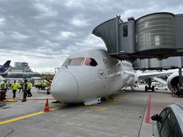 Lufthansa 787 Nose Gear Collapses at Frankfurt Airport While Crew Onboard
A Lufthansa Boeing 787 Dreamliner suffered a nose landing gear collapse while parked at a Frankfurt Airport gate with crew aboard.
NEWS
READ MORE »
Lufthansa 787 Nose Gear Collapses at Frankfurt Airport While Crew Onboard
A Lufthansa Boeing 787 Dreamliner suffered a nose landing gear collapse while parked at a Frankfurt Airport gate with crew aboard.
NEWS
READ MORE »
 Cirrus Vision Jet Lands Safely After Engine Failure Over Virginia
A Cirrus Vision Jet pilot landed safely after an engine failure, with no injuries reported. Here's what happened and what investigators know so far.
NEWS
READ MORE »
Cirrus Vision Jet Lands Safely After Engine Failure Over Virginia
A Cirrus Vision Jet pilot landed safely after an engine failure, with no injuries reported. Here's what happened and what investigators know so far.
NEWS
READ MORE »
 Cessna Citation M2 Gen3 Completes First Flight, Moving Closer to Certification
Textron Aviation's Cessna Citation M2 Gen3 light jet completed its maiden flight, marking a key step toward FAA certification and customer deliveries.
NEWS
READ MORE »
Cessna Citation M2 Gen3 Completes First Flight, Moving Closer to Certification
Textron Aviation's Cessna Citation M2 Gen3 light jet completed its maiden flight, marking a key step toward FAA certification and customer deliveries.
NEWS
READ MORE »
More than just headlines.
Get unlimited ad-free access to in-depth aviation news, premium stories, and exclusive insights other sites don't cover.
- Ad-free browsing on AeroXplorer
- Unlimited access to premium and exclusive articles
- Higher photo upload limits & commissions on sales
- Free access to Jetstream Magazine on higher tiers
- Ad-free browsing
- Sell aviation photos with 60% commission
- First week free!
- Everything in Basic+
- Unlimited premium articles
- Sell aviation photos with 70% commission
- Free Digital subscription to Jetstream Magazine
- First week free!
- Everything in Basic+ and Pro
- Sell aviaiton photos with 80% commission
- Early access to exclusive stories
- Free Digital+Print subscription to Jetstream Magazine